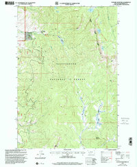
1997 Map of Stewart Mountain
USGS Topo · Published 2001About this map
The high peaks and drainages of Beaverhead National Forest dominate this landscape, centered on the towering Stewart Mountain. The map details a backcountry network of trails and primitive roads that supported mid-century resource extraction and forest management, illustrated by the presence of the Steel Creek Guard Station and the Steel Creek Campground. Historically significant mining claims are scattered throughout the drainages, including the Maynard Mine near Steel Creek and the Arnold Mine to the west. The hydrology of the area is particularly complex, defined by high-elevation water bodies like Baldy Lake and Stewart Lake, which feed into a system of named creeks including Wisconsin Creek and Warm Springs Creek. The division between the Wisdom Ranger District and the Pioneer District marks the administrative boundaries within this wilderness area at the end of the twentieth century.
Find a feature on this map
36 named features on this map. Tap any name to fly to it.
Don’t see what you’re looking for? This feature index may not catch every label — zoom into the map to look around manually.
Map Details
Editions of this 1997 Stewart Mountain Map
This is the sole edition of this map. No revisions or reprints were ever made.
Other maps of this area

1955 · Dillon
USGS Topo · 1:250,000

1957 · Dillon
USGS Topo · 1:250,000

1958 · Dillon
USGS Topo · 1:250,000

1959 · Polaris
USGS Topo · 1:62,500

1962 · Dillon
USGS Topo · 1:250,000

1962 · Wisdom
USGS Topo · 1:24,000

1962 · Mud Lake
USGS Topo · 1:24,000

1962 · Stewart Mountain
USGS Topo · 1:24,000

1962 · Proposal Rock
USGS Topo · 1:24,000

1965 · Dillon
USGS Topo · 1:250,000