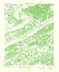
1935 Map of Stickleyville
USGS Topo · Published 1935About this map
Stickleyville and the surrounding rural landscape of Lee and Scott Counties are defined here by a series of prominent ridgelines, including Wallen Ridge, Powell Mountain, and Newman Ridge. This mid-1930s survey captures a deeply established community of small settlements and educational outposts such as Carters Institute and Cedar Front Sch, highlighting the importance of local institutions in this mountain terrain. The presence of Osborne Mill and several family-named burial sites, including Graham Cem and Robinette Cem, indicates a decentralized agrarian economy tied closely to the valleys formed by the Powell River and the North Fork Clinch River.
Find a feature on this map
64 named features on this map. Tap any name to fly to it.
Don’t see what you’re looking for? This feature index may not catch every label — zoom into the map to look around manually.
Map Details
Editions of this 1935 Stickleyville Map
This is the sole edition of this map. No revisions or reprints were ever made.
Other maps of this area

1887 · Jonesville
USGS Topo · 1:125,000

1891 · Jonesville
USGS Topo · 1:125,000

1894 · Estillville
USGS Topo · 1:125,000

1916 · Nolansburg
USGS Topo · 1:48,000

1919 · Nolansburg
USGS Topo · 1:62,500

1921 · Big Stone Gap
USGS Topo · 1:48,000

1922 · Big Stone Gap
USGS Topo · 1:62,500

1929 · Big Stone Gap
USGS Topo · 1:62,500

1935 · Kyles Ford
USGS Topo · 1:24,000

1935 · Looneys Gap
USGS Topo · 1:24,000