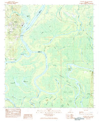
1983 Map of Stiggings Lake
USGS Topo · Published 1983About this map
Ft Stoddard and the site of Old Ft Stoddard Mt Vernon Landing anchor this 1983 survey of the complex riverine landscape where the Mobile and Tensaw rivers diverge. The area is defined by a dense network of sloughs and cutoffs, including Minnow Slough and Little Slough, which create a mosaic of islands such as Aikin Island and Fisher Island. This map reveals the historical layering of the region, from the ancient Indian Mound near Mound Creek to the mid-century community infrastructure of Mt Olive Ch, Pine Grove Ch, and Belsaw Sch. The reliance on water transport is evident through numerous river access points like Meathers Landing and Bryant Landing, showing how the swampy terrain between Mobile River and Tensaw River remained largely inaccessible by road, save for a few private tracks.
Find a feature on this map
56 named features on this map. Tap any name to fly to it.
Don’t see what you’re looking for? This feature index may not catch every label — zoom into the map to look around manually.
Map Details
Editions of this 1983 Stiggings Lake Map
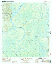
2 editions found
Other maps of this area

1941 · Bay Minette
USGS Topo · 1:62,500

1941 · Creola
USGS Topo · 1:62,500

1943 · Creola
USGS Topo · 1:62,500

1943 · Bay Minette
USGS Topo · 1:62,500

1943 · Tensaw
USGS Topo · 1:62,500

1943 · Citronelle
USGS Topo · 1:62,500

1944 · Tensaw
USGS Topo · 1:62,500

1946 · Citronelle
USGS Topo · 1:62,500

1953 · Andalusia
USGS Topo · 1:250,000

1953 · Hattiesburg
USGS Topo · 1:250,000