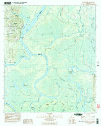
1983 Map of Stiggings Lake
USGS Topo · Published 1983About this map
Ft Stoddard sits along the western bank of the Mobile River, serving as a focal point for this intricate riverine landscape on the Mobile and Baldwin county line. The area is characterized by a dense network of water bodies and marshlands, where the Tensaw River and Mobile River diverge into numerous sloughs and lakes, such as Stiggins Lake and Gumbo Lake. Traces of earlier history are evident at Old Ft Stoddard and the Indian Mound located on Mound Island, indicating long-term human presence along these waterways. Local community life is centered near the riverbanks at Mt Olive Ch, Pine Grove Ch, and Belsaw Sch. The map also documents a series of river access points, including Meathers Landing, Bryant Landing, and Rice Creek Landing, which emphasize the historical importance of water-based transport and fishing in this delta environment.
Find a feature on this map
59 named features on this map. Tap any name to fly to it.
Don’t see what you’re looking for? This feature index may not catch every label — zoom into the map to look around manually.
Map Details
Editions of this 1983 Stiggings Lake Map
2 editions found
Other maps of this area

1941 · Bay Minette
USGS Topo · 1:62,500

1941 · Creola
USGS Topo · 1:62,500

1943 · Creola
USGS Topo · 1:62,500

1943 · Bay Minette
USGS Topo · 1:62,500

1943 · Tensaw
USGS Topo · 1:62,500

1943 · Citronelle
USGS Topo · 1:62,500

1944 · Tensaw
USGS Topo · 1:62,500

1946 · Citronelle
USGS Topo · 1:62,500

1953 · Andalusia
USGS Topo · 1:250,000

1953 · Hattiesburg
USGS Topo · 1:250,000