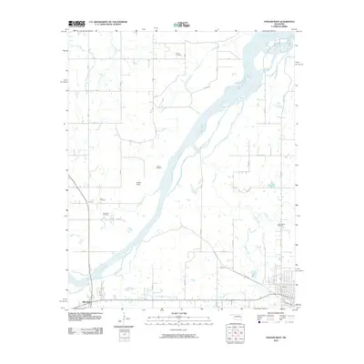
2010 Map of Stigler West
USGS Topo · Published 2010About this map
The Canadian River dominates this portion of Haskell County, carving a wide path through the landscape northeast of Whitefield. This 2010 survey illustrates a rural Oklahoma environment where the drainage network—including Jackson Creek, Taloka Creek, and Snake Creek—dictates the placement of family and community landmarks. Genealogists will find several significant burial sites across the township, such as Cramp Cemetery in the north and Sand Spring Cemetery to the east, along with McClure Cemetery and the Starr Cemetery. The terrain is generally level river bottomland, interrupted by notable elevations like Turkey Knob and the small-scale infrastructure of rural routes like Garland Rd and Tomaha Rd. The map provides a clear view of the section lines and rural dwellings that characterize the area's modern settlement pattern just south of the Canadian's broad channel.
Find a feature on this map
26 named features on this map. Tap any name to fly to it.
Don’t see what you’re looking for? This feature index may not catch every label — zoom into the map to look around manually.
Map Details
Editions of this 2010 Stigler West Map
This is the sole edition of this map. No revisions or reprints were ever made.
Other maps of this area

1900 · Sansbois
USGS Topo · 1:125,000

1909 · Sans Bois
USGS Topo · 1:125,000

1911 · Sansbois
USGS Topo · 1:125,000

1946 · Fort Smith
USGS Topo · 1:250,000

1962 · Stigler East
USGS Topo · 1:24,000

1962 · Stigler West
USGS Topo · 1:24,000
1963 · Stigler NE
USGS Topo · 1:24,000

1963 · Porum
USGS Topo · 1:24,000
1963 · Holt Mountain
USGS Topo · 1:24,000
1963 · Warner
USGS Topo · 1:24,000