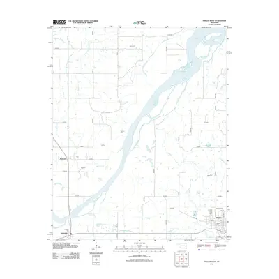
2012 Map of Stigler West
USGS Topo · Published 2012About this map
The Canadian River cuts diagonally through this portion of Haskell County, defining the local geography and historical settlement patterns of the early twenty-first century. On the eastern edge, the town of Stigler serves as a primary hub, with residential streets like NW L St and NW H St extending toward the Stigler Cem. To the west, the smaller communities of Whitefield and Briartown anchor the rural landscape, each maintaining its own distinct burial grounds such as Whitefield Cem and Starr Cem. This map reveals a high density of family and community cemeteries, including Sand Spring Cem and Cramp Cem, which provide significant points of interest for genealogical research. The terrain is marked by prominent features like Turkey Knob and a network of creeks, including Taloka Cr and Snake Cr, that feed into the river valley.
Find a feature on this map
53 named features on this map. Tap any name to fly to it.
Don’t see what you’re looking for? This feature index may not catch every label — zoom into the map to look around manually.
Map Details
Editions of this 2012 Stigler West Map
This is the sole edition of this map. No revisions or reprints were ever made.
Other maps of this area

1900 · Sansbois
USGS Topo · 1:125,000

1909 · Sans Bois
USGS Topo · 1:125,000

1911 · Sansbois
USGS Topo · 1:125,000

1946 · Fort Smith
USGS Topo · 1:250,000

1962 · Stigler East
USGS Topo · 1:24,000

1962 · Stigler West
USGS Topo · 1:24,000
1963 · Stigler NE
USGS Topo · 1:24,000

1963 · Porum
USGS Topo · 1:24,000
1963 · Holt Mountain
USGS Topo · 1:24,000
1963 · Warner
USGS Topo · 1:24,000