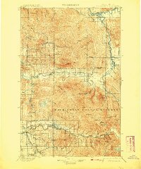
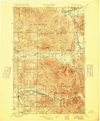
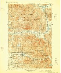
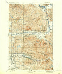
1901 Map of Stilaguamish
USGS Topo · Published 1908About this map
Silverton and Gold Basin appear as active settlements along the South Fork Stillaguamish River during this late nineteenth-century survey. The landscape is defined by the heavy presence of the Washington Forest Reserve and a network of high-altitude peaks, including Three Fingers and White Horse Mt. The southern corridor is particularly industrial for the era, with the Northern Pacific RR pushing through Granite Falls to serve the mining interests near the Monte Cristo region. To the north, the convergence of the Sauk River and Suiattle River near Mansford Prairie illustrates the importance of river basins for early homesteading and transit before the establishment of modern highway systems. Small settlements like Oso and Darrington provide early anchors for the logging and prospecting communities that defined this portion of the Cascades.
Find a feature on this map
112 named features on this map. Tap any name to fly to it.
Don’t see what you’re looking for? This feature index may not catch every label — zoom into the map to look around manually.
Map Details
Editions of this 1901 Stilaguamish Map
6 editions found

Other maps of this area

1895 · Snohomish
USGS Topo · 1:125,000

1897 · Seattle
USGS Topo · 1:125,000

1899 · Glacier Peak
USGS Topo · 1:125,000

1899 · Stillaguamish
USGS Topo · 1:125,000

1901 · Glacier Peak
USGS Topo · 1:125,000

1901 · Stilaguamish
USGS Topo · 1:125,000

1902 · Skykomish
USGS Topo · 1:125,000

1905 · Skykomish
USGS Topo · 1:125,000

1909 · Mt Baker
USGS Topo · 1:192,000

1911 · Mount Vernon
USGS Topo · 1:125,000