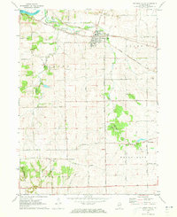
1971 Map of Stillman Valley
USGS Topo · Published 1973About this map
Stillman Valley sits at the junction of two major rail lines in the early 1970s, serving as a hub for the surrounding agricultural landscape of northern Ogle County. The Chicago Milwaukee St Paul and Pacific and the Chicago and North Western railroads crisscross the terrain, following the natural drainage of Stillman Creek and its tributaries. The map reveals a transition from the riverine environment of the Rock River in the northwest to the prominent glacial topography of Big Mound in the east.
Find a feature on this map
55 named features on this map. Tap any name to fly to it.
Don’t see what you’re looking for? This feature index may not catch every label — zoom into the map to look around manually.
Map Details
Editions of this 1971 Stillman Valley Map
2 editions found
Other maps of this area

1917 · Kings
USGS Topo · 1:62,500

1918 · Dixon
USGS Topo · 1:62,500

1918 · Kings
USGS Topo · 1:62,500

1922 · Oregon
USGS Topo · 1:62,500

1924 · Oregon
USGS Topo · 1:62,500

1949 · Camp Grant
USGS Topo · 1:24,000

1950 · Dixon
USGS Topo · 1:62,500

1952 · Rochelle
USGS Topo · 1:62,500

1954 · Rockford
USGS Topo · 1:250,000

1955 · Rockford
USGS Topo · 1:250,000