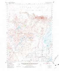
1950 Map of Stillwater
USGS Topo · Published 1983About this map
The Carson Sink Alkali Flat (Depression) dominates the northern reaches of this mid-century survey, a landscape defined by the complex water systems of the Carson River. The map illustrates the intensive irrigation and water management of the era, visible through the network of the Stillwater Irrigation Drain and landmarks like Wolf Dam and Sagouspe Dam. These structures support the lush Indian Lakes region, including Big Indian Lake and Papoose Lake, which contrast sharply with the surrounding Alkali Flat and Sand Dunes.
Find a feature on this map
47 named features on this map. Tap any name to fly to it.
Don’t see what you’re looking for? This feature index may not catch every label — zoom into the map to look around manually.
Map Details
Editions of this 1950 Stillwater Map
4 editions found
Other maps of this area

1908 · Carson Sink
USGS Topo · 1:250,000

1910 · Carson Sink
USGS Topo · 1:250,000

1950 · Stillwater
USGS Topo · 1:62,500

1951 · Carson Lake
USGS Topo · 1:62,500

1951 · Soda Lake
USGS Topo · 1:62,500

1951 · Carson Sink
USGS Topo · 1:62,500

1951 · Desert Peak
USGS Topo · 1:62,500

1951 · Fallon
USGS Topo · 1:62,500

1957 · Reno
USGS Topo · 1:250,000

1959 · Reno
USGS Topo · 1:250,000