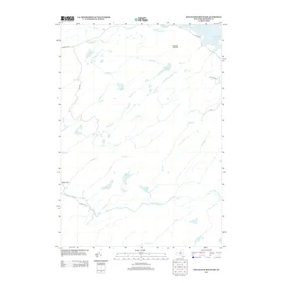
2013 Map of Stillwater Mountain
USGS Topo · Published 2013About this map
Stillwater Mountain dominates the northeast corner of this Adirondack landscape, which is defined by an intricate network of waterways and glacial ponds. The expansive Stillwater Reservoir reaches into the upper margins, fed by Lizard Spring Brook. This 2013 survey illustrates a wilderness largely untouched by dense settlement, where topography is mapped through the flow of the Independence River and the positioning of named clearings like Balsam Flats. Transportation is limited to narrow corridors such as Big Moose Rd and McCarty Rd, which provide the only primary access points into this remote region. The map captures a transition between the elevated peaks and the low-lying wetlands of Polack Swamp Rd and Grass Pond, offering a detailed look at the drainage patterns of Moose Cr and Fourth Cr.
Find a feature on this map
29 named features on this map. Tap any name to fly to it.
Don’t see what you’re looking for? This feature index may not catch every label — zoom into the map to look around manually.
Map Details
Editions of this 2013 Stillwater Mountain Map
This is the sole edition of this map. No revisions or reprints were ever made.
Other maps of this area

1901 · Old Forge
USGS Topo · 1:62,500

1903 · Big Moose
USGS Topo · 1:62,500

1912 · Number Four
USGS Topo · 1:62,500

1912 · Mc Keever
USGS Topo · 1:62,500

1915 · Number Four
USGS Topo · 1:62,500

1950 · Utica
USGS Topo · 1:250,000

1954 · Old Forge
USGS Topo · 1:62,500

1954 · Big Moose
USGS Topo · 1:62,500

1957 · Utica
USGS Topo · 1:250,000
1957 · Number Four
USGS Topo · 1:62,500