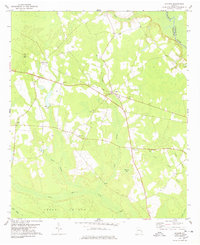
1978 Map of Stilson
USGS Topo · Published 1978About this map
The Ogeechee River defines the northeastern boundary of this Bulloch County landscape, where the settlement of Stilson serves as a central hub. The community is linked to the surrounding countryside by the Old RR Grade, reflecting the historical importance of rail transit through the piney woods and wetlands of south Georgia. Numerous country churches, including Old Fellowship Ch, New Fellowship Ch, and Friendship Ch, are scattered across the terrain, indicating a deeply rooted rural social structure. The geography is characterized by several drainage branches like Iric Branch and Pole Branch that feed into Upper Black Creek. Distinctive landforms such as Sand Ridge and Cooks Island rise above the low-lying basins, including Brannen Bay, highlighting the varied topography of the coastal plain during the late 1970s.
Find a feature on this map
25 named features on this map. Tap any name to fly to it.
Don’t see what you’re looking for? This feature index may not catch every label — zoom into the map to look around manually.
Map Details
Editions of this 1978 Stilson Map
This is the sole edition of this map. No revisions or reprints were ever made.
Other maps of this area

1919 · Egypt
USGS Topo · 1:62,500

1920 · Pembroke
USGS Topo · 1:62,500

1920 · Meldrim
USGS Topo · 1:62,500

1921 · Brooklet
USGS Topo · 1:62,500

1939 · Egypt
USGS Topo · 1:62,500

1942 · Meldrim
USGS Topo · 1:62,500

1943 · Brooklet
USGS Topo · 1:62,500

1943 · Egypt
USGS Topo · 1:62,500

1947 · Savannah
USGS Topo · 1:250,000

1948 · Savannah
USGS Topo · 1:250,000