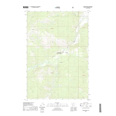
2020 Map of Stine Mountain
USGS Topo · Published 2020About this map
The Wise River cuts a central path through this high-elevation reach of the Beaverhead National Forest, where the landscape is defined by the drainage networks of the Pioneer Mountains. Stine Mtn and Sugarloaf Hill rise as prominent landmarks above a series of drainages, including Pattengill Creek and Boulder Cr. The map shows a terrain shaped by alpine features like the Grouse Lakes and distinctive geological formations such as Eagle Rock and Needle Rock. Human presence is sparse, represented primarily by forest routes like Pattengill Rd and Harriet Lou Rd, which provide access to Ross Gulch and the surrounding wilderness. This 2020 survey documents the modern state of these protected lands, tracing the numerous tributaries like Stine Cr and Fourth of July Cr that feed into the region's primary river system.
Find a feature on this map
41 named features on this map. Tap any name to fly to it.
Don’t see what you’re looking for? This feature index may not catch every label — zoom into the map to look around manually.
Map Details
Editions of this 2020 Stine Mountain Map
This is the sole edition of this map. No revisions or reprints were ever made.
Other maps of this area

1893 · Dillon
USGS Topo · 1:250,000

1955 · Dillon
USGS Topo · 1:250,000

1957 · Dillon
USGS Topo · 1:250,000

1958 · Dillon
USGS Topo · 1:250,000

1958 · Vipond Park
USGS Topo · 1:62,500

1961 · Wise River
USGS Topo · 1:24,000

1962 · Dillon
USGS Topo · 1:250,000
1962 · Dickie Hills
USGS Topo · 1:24,000
1962 · Foolhen Mountain
USGS Topo · 1:24,000

1965 · Dillon
USGS Topo · 1:250,000