
1961 Map of Wise River
USGS Topo · Published 1964About this map
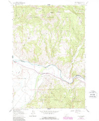
The confluence of the Wise River and the Big Hole River serves as the focal point for this 1961 field-checked survey of southwestern Montana. This area within the Beaverhead National Forest features the small community of Wise River and the rural junction at Pattersons Corner. The landscape is defined by the transition from the broad river valleys to the high elevations of Granulated Mountain and Little Granulated Mountain.
Find a feature on this map
35 named features on this map. Tap any name to fly to it.
Don’t see what you’re looking for? This feature index may not catch every label — zoom into the map to look around manually.
Map Details
Editions of this 1961 Wise River Map
2 editions found
Other maps of this area

1893 · Dillon
USGS Topo · 1:250,000

1955 · Dillon
USGS Topo · 1:250,000

1957 · Dillon
USGS Topo · 1:250,000

1958 · Dillon
USGS Topo · 1:250,000

1958 · Vipond Park
USGS Topo · 1:62,500
1961 · Burnt Mountain
USGS Topo · 1:24,000
1961 · Dickie Peak
USGS Topo · 1:24,000

1961 · Dewey
USGS Topo · 1:24,000

1962 · Dillon
USGS Topo · 1:250,000

1962 · Lincoln Gulch
USGS Topo · 1:24,000