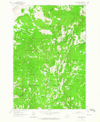
1961 Map of Dickie Peak
USGS Topo · Published 1964About this map
Continental Divide winds through this high-elevation landscape in the early 1960s, serving as the rugged spine between Deerlodge National Forest and Beaverhead National Forest. This region, split by the Deer Lodge and Silver Bow County line, is defined by its deep mining and ranching heritage. Local extraction is evidenced by the Hungry Hill Mine, Mary Ann Mine, and the specifically named Pine Dale Cow Cabin Mine. Small pockets of activity like French Town and Johnson Park sit among a dense network of gulches and creeks, including German Gulch and French Gulch. The presence of several meadows and lakes, such as Selway Meadows and Fish Lake, suggests a landscape used for seasonal grazing and wilderness access during this era of forest management.
Find a feature on this map
41 named features on this map. Tap any name to fly to it.
Don’t see what you’re looking for? This feature index may not catch every label — zoom into the map to look around manually.
Map Details
Editions of this 1961 Dickie Peak Map
2 editions found
Other maps of this area

1889 · Helena
USGS Topo · 1:250,000

1893 · Helena
USGS Topo · 1:250,000

1893 · Dillon
USGS Topo · 1:250,000

1899 · Helena
USGS Topo · 1:250,000

1903 · Helena
USGS Topo · 1:250,000

1908 · Philipsburg
USGS Topo · 1:125,000

1947 · Butte
USGS Topo · 1:250,000

1955 · Dillon
USGS Topo · 1:250,000

1957 · Dillon
USGS Topo · 1:250,000

1958 · Butte
USGS Topo · 1:250,000