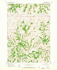
1962 Map of Stitzer
USGS Topo · Published 1964About this map
The Chicago and North Western railroad forms a primary east-west corridor across the northern reaches of this Grant County landscape, connecting the rural communities of Lancaster Junction and Preston. The terrain is deeply carved by the Platte River and its numerous tributaries, including Leggett Creek, Newell Creek, and Crow Branch. This drainage pattern shapes the boundaries of the civil townships of Fennimore, Wingville, Liberty, and Clifton, which meet in this dissected upland area.
Find a feature on this map
18 named features on this map. Tap any name to fly to it.
Don’t see what you’re looking for? This feature index may not catch every label — zoom into the map to look around manually.
Map Details
Editions of this 1962 Stitzer Map
This is the sole edition of this map. No revisions or reprints were ever made.
Other maps of this area

1900 · Lancaster
USGS Topo · 1:125,000

1902 · Mineral Point
USGS Topo · 1:125,000

1904 · Lancaster
USGS Topo · 1:125,000

1905 · Richland Center
USGS Topo · 1:125,000

1908 · Lancaster
USGS Topo · 1:125,000

1933 · Boscobel
USGS Topo · 1:62,500

1952 · Rewey
USGS Topo · 1:24,000

1952 · Montfort
USGS Topo · 1:24,000

1958 · La Crosse
USGS Topo · 1:250,000

1959 · Dubuque
USGS Topo · 1:250,000