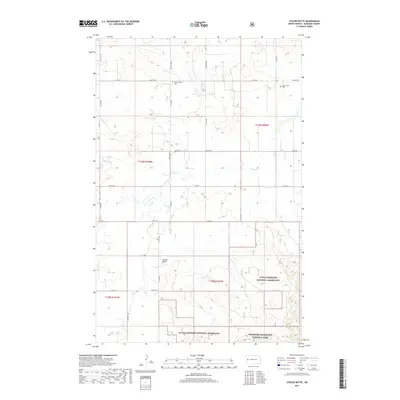
2017 Map of Stocke Butte
USGS Topo · Published 2017About this map
Stocke Butte rises over the high plains of McKenzie County, marking a landscape defined by the drainage systems of Cherry Cr and Red Wing Cr. This northern plains environment is notable for the convergence of protected public lands, including the northern portions of the Theodore Roosevelt National Park and the expansive Little Missouri National Grassland. The map reveals the imprint of Scandinavian and German pioneer settlement through surviving landmarks like the Zoar Lutheran Cem and the Olson Farm Cem, which reflect the community centers established by homesteading families in the early 20th century. While the grid of section lines and gravel routes like Co Rd 30 and 22nd St NW organizes the territory, the presence of the national park boundary suggests the rugged transition toward the Badlands terrain that lies just beyond the horizon.
Find a feature on this map
30 named features on this map. Tap any name to fly to it.
Don’t see what you’re looking for? This feature index may not catch every label — zoom into the map to look around manually.
Map Details
Editions of this 2017 Stocke Butte Map
This is the sole edition of this map. No revisions or reprints were ever made.
Other maps of this area

1953 · Watford City
USGS Topo · 1:250,000

1957 · Watford City
USGS Topo · 1:250,000

1958 · Long X Divide
USGS Topo · 1:24,000

1958 · Sperati Point
USGS Topo · 1:24,000

1958 · Stocke Butte
USGS Topo · 1:24,000

1958 · Tepee Buttes
USGS Topo · 1:24,000

1967 · Watford City
USGS Topo · 1:250,000

1972 · Bear Butte
USGS Topo · 1:24,000

1972 · Rawson
USGS Topo · 1:24,000

1978 · Arnegard
USGS Topo · 1:24,000