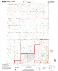
1997 Map of Stocke Butte
USGS Topo · Published 2001About this map
Stocke Butte rises above the drainage basin of Cherry Creek in this late twentieth-century survey of western North Dakota. The landscape is defined by the intersection of rural township governance and federal land management, with the Town Hall serving as a central landmark for the surrounding Elsworth district. Local life and history are anchored by institutions like the Zoar Ch and the adjacent Zoar Ch Cem, alongside the Red Wing Sch located near Red Wing Creek.
Find a feature on this map
14 named features on this map. Tap any name to fly to it.
Don’t see what you’re looking for? This feature index may not catch every label — zoom into the map to look around manually.
Map Details
Editions of this 1997 Stocke Butte Map
This is the sole edition of this map. No revisions or reprints were ever made.
Other maps of this area

1953 · Watford City
USGS Topo · 1:250,000

1957 · Watford City
USGS Topo · 1:250,000

1958 · Long X Divide
USGS Topo · 1:24,000

1958 · Sperati Point
USGS Topo · 1:24,000

1958 · Stocke Butte
USGS Topo · 1:24,000

1958 · Tepee Buttes
USGS Topo · 1:24,000

1967 · Watford City
USGS Topo · 1:250,000

1972 · Bear Butte
USGS Topo · 1:24,000

1972 · Rawson
USGS Topo · 1:24,000

1978 · Arnegard
USGS Topo · 1:24,000