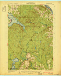
1931 Map of Stockholm
USGS Topo · Published 1931About this map
Stockholm and the surrounding Swedish-settled townships of northern Aroostook County appear here in a portrait of the early 20th-century timber and rail era. The Bangor and Aroostook railroad defines the region's movement, linking the village of Stockholm with small outposts like Jemtland and industrial spurs at Collins Siding. The map illustrates a landscape transitioning from wild forest to established homesteads, punctuated by a remarkable density of local institutions, including the Herquist Sch, East Jemtland Sch, and Lebanon Sch.
Find a feature on this map
64 named features on this map. Tap any name to fly to it.
Don’t see what you’re looking for? This feature index may not catch every label — zoom into the map to look around manually.
Map Details
Editions of this 1931 Stockholm Map
4 editions found
Other maps of this area

1921 · Van Buren
USGS Topo · 1:250,000

1927 · Stockholm
USGS Topo · 1:48,000

1927 · Square Lake
USGS Topo · 1:48,000

1929 · Portage
USGS Topo · 1:62,500

1929 · Caribou
USGS Topo · 1:48,000

1930 · Fort Fairfield
USGS Topo · 1:48,000

1931 · Square Lake
USGS Topo · 1:62,500

1931 · Van Buren
USGS Topo · 1:48,000

1931 · Portage
USGS Topo · 1:62,500

1931 · Stockholm
USGS Topo · 1:62,500