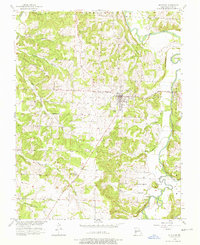
1956 Map of Stockton
USGS Topo · Published 1976About this map
The county seat of Stockton sits at the heart of this mid-1950s survey, surrounded by the winding drainage systems of the Sac River and Little Sac River. The landscape is defined by its numerous named watercourses, including Flood Branch, Blue Branch, and Pollock Creek, which carve through the Cedar County terrain. This map reveals a distributed rural community anchored by local landmarks such as Excelsior Ch. and Gum Springs Ch. to the west, and Prairie Valley Ch. near King Hill in the southeast.
Find a feature on this map
32 named features on this map. Tap any name to fly to it.
Don’t see what you’re looking for? This feature index may not catch every label — zoom into the map to look around manually.
Map Details
Editions of this 1956 Stockton Map
3 editions found
Other maps of this area

1886 · Stockton
USGS Topo · 1:125,000

1939 · Caplinger Mills
USGS Topo · 1:24,000

1939 · Arnica
USGS Topo · 1:24,000

1939 · Filley
USGS Topo · 1:24,000

1940 · Filley
USGS Topo · 1:24,000

1941 · Caplinger Mills
USGS Topo · 1:24,000

1941 · Arnica
USGS Topo · 1:24,000

1954 · Springfield
USGS Topo · 1:250,000
1956 · Stockton
USGS Topo · 1:24,000
1956 · Bearcreek
USGS Topo · 1:24,000