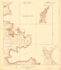
1924 Map of Stokes Mountain
USGS Topo · Published 1924About this map
Stokes Mountain and its surrounding canyons dominate this 1920s topography, revealing a transitional landscape in Tulare County. The map details the intricate drainage patterns of Sand Creek and Cottonwood Creek as they descend toward the Woodlake Valley. Notable for local researchers is the Elda School, which served as a focal point for the rural community during this period of development. This survey reflects the region's agricultural and transit infrastructure at a time when the A. T. & S. F. railroad facilitated movement through the valley floor. The specialized scale of this sheet provides high-resolution contouring of the foothills, contrasting with the broader surveys conducted in earlier years.
Find a feature on this map
8 named features on this map. Tap any name to fly to it.
Don’t see what you’re looking for? This feature index may not catch every label — zoom into the map to look around manually.
Map Details
Editions of this 1924 Stokes Mountain Map
3 editions found
Other maps of this area

1921 · Squaw Valley
USGS Topo · 1:31,680

1921 · Stokes Mountain
USGS Topo · 1:24,000

1922 · Trimmer
USGS Topo · 1:96,000

1923 · Sultana
USGS Topo · 1:31,680

1924 · Citrus Cove
USGS Topo · 1:31,680

1924 · Dinuba
USGS Topo · 1:125,000

1924 · Stokes Mountain
USGS Topo · 1:31,680

1926 · Ivanhoe
USGS Topo · 1:31,680

1927 · Monson
USGS Topo · 1:31,680

1928 · Lemon Cove
USGS Topo · 1:31,680