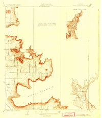
1924 Map of Stokes Mountain
USGS Topo · Published 1929About this map
Stokes Mountain dominates this portion of Tulare County, rising sharply above the fertile basin of Woodlake Valley. Surveyors T.H. Moncure and C.A. Stonesifer recorded a landscape defined by dramatic elevation changes, where the agricultural potential of the valley floor meets the steep, island-like ridges of the Sierra Nevada foothills. The cultural footprint of the early 1920s is visible in the isolated placement of the Elda School and the presence of the A T & S F railroad skirts the southwestern edge of the terrain.
Find a feature on this map
7 named features on this map. Tap any name to fly to it.
Don’t see what you’re looking for? This feature index may not catch every label — zoom into the map to look around manually.
Map Details
Editions of this 1924 Stokes Mountain Map
3 editions found
Other maps of this area

1921 · Squaw Valley
USGS Topo · 1:31,680

1921 · Stokes Mountain
USGS Topo · 1:24,000

1922 · Trimmer
USGS Topo · 1:96,000

1923 · Sultana
USGS Topo · 1:31,680

1924 · Citrus Cove
USGS Topo · 1:31,680

1924 · Dinuba
USGS Topo · 1:125,000

1924 · Stokes Mountain
USGS Topo · 1:31,680

1926 · Ivanhoe
USGS Topo · 1:31,680

1927 · Monson
USGS Topo · 1:31,680

1928 · Lemon Cove
USGS Topo · 1:31,680