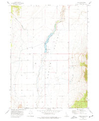
1973 Map of Stone
USGS Topo · Published 1977About this map
Stone sits as a quiet hub within the wide expanse of the Curlew Valley along the Idaho-Utah border. This 1970s survey captures a landscape defined by the management of water in an arid environment, centered on the Stone Reservoir and the meandering path of Deep Creek. The presence of numerous irrigation and stock wells, such as Well 4623 and Well 4559, underscores the agricultural dependency of the region. Local recreation and land use are evidenced by the Curlew Campground and Boat Ramp near the reservoir dam, while the rugged margins are marked by features like North Canyon and scattered extraction sites including a Borrow Pit and Gravel Pit. The map documents the rural infrastructure of Oneida County before significant modern changes, preserving the exact locations of ranching landmarks like the Corral near the northern valley floor.
Find a feature on this map
26 named features on this map. Tap any name to fly to it.
Don’t see what you’re looking for? This feature index may not catch every label — zoom into the map to look around manually.
Map Details
Editions of this 1973 Stone Map
This is the sole edition of this map. No revisions or reprints were ever made.
Other maps of this area

1954 · Pocatello
USGS Topo · 1:250,000

1954 · Brigham City
USGS Topo · 1:250,000

1958 · Pocatello
USGS Topo · 1:250,000

1958 · Brigham City
USGS Topo · 1:250,000

1962 · Brigham City
USGS Topo · 1:250,000

1968 · Rattlesnake Pass
USGS Topo · 1:24,000

1968 · Snowville
USGS Topo · 1:24,000

1968 · Monument Peak NE
USGS Topo · 1:24,000

1973 · The Cove
USGS Topo · 1:24,000
1973 · Badger Hole Spring
USGS Topo · 1:24,000