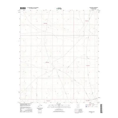
2017 Map of Stone Well
USGS Topo · Published 2017About this map
Stone Well occupies a centralized position within this arid landscape of southern Otero County, where the topography is defined by subtle drainage patterns and localized relief. The map reveals a network of county routes, including Co Rd F037 and Co Rd F067, which traverse the high desert terrain. These roads likely follow established paths between vital water sources and ranching outposts in a region where the Public Land Survey System has meticulously partitioned the land into sections within townships like t23s r12e and t23s r13e. The presence of such specifically named infrastructure as Co Rd F035 and Co Rd F034 underscores the ongoing importance of access and movement through this remote part of New Mexico, providing a clear view of the area's rural development and land management as it existed in the mid-2010s.
Find a feature on this map
13 named features on this map. Tap any name to fly to it.
Don’t see what you’re looking for? This feature index may not catch every label — zoom into the map to look around manually.
Map Details
Editions of this 2017 Stone Well Map
This is the sole edition of this map. No revisions or reprints were ever made.
Other maps of this area

1940 · Bassett Lake
USGS Topo · 1:62,500

1943 · Pendejo Wash
USGS Topo · 1:62,500

1943 · Bassett Lake
USGS Topo · 1:62,500

1954 · Carlsbad
USGS Topo · 1:250,000

1958 · Carlsbad
USGS Topo · 1:250,000

1959 · Alamo Mountain
USGS Topo · 1:62,500

1975 · Alamo Mountain NE
USGS Topo · 1:24,000
1975 · B T Ranch
USGS Topo · 1:24,000
1979 · Otero Mesa South
USGS Topo · 1:24,000

1979 · Crow Flats
USGS Topo · 1:100,000