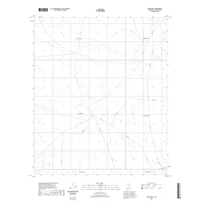
2020 Map of Stone Well
USGS Topo · Published 2020About this map
7 B T Ranch and the outlier of Alamo Mountain NE define the human footprint in this expansive portion of Otero County. The landscape is characterized by its high desert isolation, where the primary infrastructure consists of a web of county roads including Co Rd F067 and Co Rd F037 that traverse the basin. This 2020 survey documents the modern layout of these remote arteries, which connect the few ranching outposts to the wider region. The map serves as a detailed record of the Public Land Survey System (PLSS) grid, showing the boundaries between t23s r12e and t23s r13e. Researchers can trace the exact routes of local connectors like Co Rd F034 and Co Rd F036 as they navigate the subtle topographic variations and dry drainage patterns of the New Mexico interior.
Find a feature on this map
15 named features on this map. Tap any name to fly to it.
Don’t see what you’re looking for? This feature index may not catch every label — zoom into the map to look around manually.
Map Details
Editions of this 2020 Stone Well Map
This is the sole edition of this map. No revisions or reprints were ever made.
Other maps of this area

1940 · Bassett Lake
USGS Topo · 1:62,500

1943 · Pendejo Wash
USGS Topo · 1:62,500

1943 · Bassett Lake
USGS Topo · 1:62,500

1954 · Carlsbad
USGS Topo · 1:250,000

1958 · Carlsbad
USGS Topo · 1:250,000

1959 · Alamo Mountain
USGS Topo · 1:62,500

1975 · Alamo Mountain NE
USGS Topo · 1:24,000
1975 · B T Ranch
USGS Topo · 1:24,000
1979 · Otero Mesa South
USGS Topo · 1:24,000

1979 · Crow Flats
USGS Topo · 1:100,000