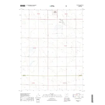
2019 Map of Stoneham
USGS Topo · Published 2019About this map
Stoneham anchors the northern portion of this High Plains survey, positioned just south of the Pawnee National Grassland. The settlement's layout is clearly defined by residential streets like Granite Ave, Marble Ave, and Flint Ave, while the nearby Prairie View Cem serves as a localized landmark for genealogists. The terrain is characterized by a grid of county roads that crisscross the arid landscape, including Co Rd 86 and Co Rd 145, illustrating the enduring section-line transport patterns of Weld County.
Find a feature on this map
31 named features on this map. Tap any name to fly to it.
Don’t see what you’re looking for? This feature index may not catch every label — zoom into the map to look around manually.
Map Details
Editions of this 2019 Stoneham Map
This is the sole edition of this map. No revisions or reprints were ever made.
Other maps of this area

1951 · Dead Horse Springs
USGS Topo · 1:24,000

1951 · Antelope Springs
USGS Topo · 1:24,000

1951 · Peace Valley School
USGS Topo · 1:24,000

1954 · Sterling
USGS Topo · 1:250,000

1958 · Sterling
USGS Topo · 1:250,000

1977 · Stoneham
USGS Topo · 1:24,000

1977 · Stoneham NE
USGS Topo · 1:24,000

1977 · Raymer NE
USGS Topo · 1:24,000

1978 · Stoneham NW
USGS Topo · 1:24,000
1978 · Raymer
USGS Topo · 1:24,000