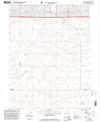
1997 Map of Stoneham
USGS Topo · Published 2000About this map
Stoneham anchors the northern reaches of this High Plains landscape, situated just south of the expansive Pawnee National Grassland. The settlement’s local character is evidenced by the presence of a Rodeo Ground near the town site, reflecting the region's enduring ranching traditions. To the west of the community lies the Prairie View Cemetery, a key site for genealogists tracing the early residents of this Weld County prairie. This 1997 revision, produced by the U.S. Department of Agriculture Forest Service, illustrates a landscape where agricultural heritage meets modern energy extraction. Numerous Oil Well sites are scattered across the terrain, indicating the industrial activity that characterizes the late 20th-century economy of the region. The map also delineates the boundary between Weld Co and Morgan Co, providing a clear look at the jurisdictional lines in this rural corridor.
Find a feature on this map
7 named features on this map. Tap any name to fly to it.
Don’t see what you’re looking for? This feature index may not catch every label — zoom into the map to look around manually.
Map Details
Editions of this 1997 Stoneham Map
This is the sole edition of this map. No revisions or reprints were ever made.
Other maps of this area

1951 · Dead Horse Springs
USGS Topo · 1:24,000

1951 · Antelope Springs
USGS Topo · 1:24,000

1951 · Peace Valley School
USGS Topo · 1:24,000

1954 · Sterling
USGS Topo · 1:250,000

1958 · Sterling
USGS Topo · 1:250,000

1977 · Stoneham
USGS Topo · 1:24,000

1977 · Stoneham NE
USGS Topo · 1:24,000

1977 · Raymer NE
USGS Topo · 1:24,000

1978 · Stoneham NW
USGS Topo · 1:24,000
1978 · Raymer
USGS Topo · 1:24,000