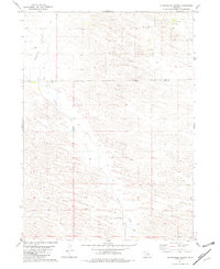
1981 Map of Stonehouse Ranch
USGS Topo · Published 1982About this map
Stonehouse Ranch and other remote outposts define the character of the Nebraska Sandhills as they appeared in the early 1980s. This ranching landscape is marked by the shifting topography of Gracie Flats and the winding path of Gracie Creek. The map records a sparse network of homesteads and essential rural infrastructure, such as the Pleasant Hill Sch, which served the scattered population across the Rock and Loup County border. Numerous Wells are documented throughout the terrain, highlighting the critical importance of water access for livestock and human habitation in this arid environment. Fine red dashed lines throughout the quadrangle provide a unique look at local fencing and field boundaries as identified through aerial photography from the mid-1970s.
Find a feature on this map
9 named features on this map. Tap any name to fly to it.
Don’t see what you’re looking for? This feature index may not catch every label — zoom into the map to look around manually.
Map Details
Editions of this 1981 Stonehouse Ranch Map
This is the sole edition of this map. No revisions or reprints were ever made.
Other maps of this area

1952 · Taylor NW
USGS Topo · 1:24,000

1952 · Burwell NW
USGS Topo · 1:24,000

1952 · Taylor NE
USGS Topo · 1:24,000

1955 · Broken Bow
USGS Topo · 1:250,000

1955 · O'Neill
USGS Topo · 1:250,000

1956 · Broken Bow
USGS Topo · 1:250,000

1959 · O'Neill
USGS Topo · 1:250,000

1969 · O'Neill
USGS Topo · 1:250,000

1981 · Bruner Lake
USGS Topo · 1:24,000

1981 · Stonehouse Ranch NW
USGS Topo · 1:24,000