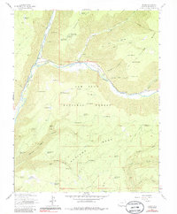
1963 Map of Stoner
USGS Topo · Published 1986About this map
The Dolores River carves a deep valley through the high country of the San Juan National Forest, anchoring the small settlement of Stoner and its associated Stoner Guard Station. This mid-century landscape is defined by the remnants of the Old Dolores Grade Railroad, which follows the river's path, and the development of the Stoner Ski Area on the northern slopes. The plateau above the canyon, including Stoner Mesa and Haycamp Mesa, is marked by an extensive network of irrigation and livestock infrastructure, evidenced by dozens of named water features like Stoner Point Reservoir and Gould Reservoir. Early transportation routes are well-preserved here, from the Stoner Pack Trail to various stock driveways that navigate the complex terrain of Garrison Canyon and Lost Canyon.
Find a feature on this map
68 named features on this map. Tap any name to fly to it.
Don’t see what you’re looking for? This feature index may not catch every label — zoom into the map to look around manually.
Map Details
Editions of this 1963 Stoner Map
4 editions found

Other maps of this area

1895 · La Plata
USGS Topo · 1:62,500

1897 · La Plata
USGS Topo · 1:62,500

1897 · Rico
USGS Topo · 1:62,500

1898 · Rico
USGS Topo · 1:62,500

1899 · La Plata
USGS Topo · 1:62,500

1899 · Rico
USGS Topo · 1:62,500

1908 · La Plata
USGS Topo · 1:62,500

1956 · Cortez
USGS Topo · 1:250,000

1958 · Cortez
USGS Topo · 1:250,000

1959 · Cortez
USGS Topo · 1:250,000