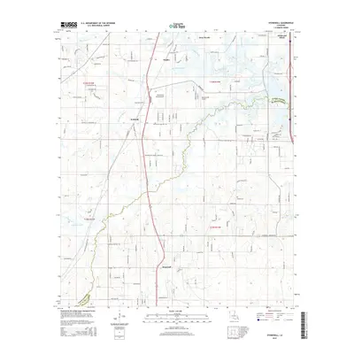
2015 Map of Stonewall
USGS Topo · Published 2015About this map
Stonewall and Keithville anchor this 2015 study of the borderlands between Caddo and De Soto Parishes, showing a landscape defined by both suburban growth and established ranching. The Union Pacific railroad runs north-south through the center of the quadrangle, paralleling the main thoroughfare that connects these communities. The drainage patterns of Cypress Bayou, Buchanan Bayou, and Boggy Bayou weave across the terrain, shaping the development of residential enclaves like Deep Woods and Wildwood South. Genealogy researchers will find the Powell Cem located south of the Cypress Bayou crossing. The presence of aviation landmarks such as the Old Hickory Ranch Airport and Bluebird Hill Airport reflects the rural-residential character of the area, where large tracts of land persist alongside newer housing developments like Staples.
Find a feature on this map
130 named features on this map. Tap any name to fly to it.
Don’t see what you’re looking for? This feature index may not catch every label — zoom into the map to look around manually.
Map Details
Editions of this 2015 Stonewall Map
This is the sole edition of this map. No revisions or reprints were ever made.
Other maps of this area

1941 · Forbing
USGS Topo · 1:31,680

1945 · Grand Cane
USGS Topo · 1:62,500

1945 · Greenwood
USGS Topo · 1:62,500

1945 · Mansfield
USGS Topo · 1:62,500

1947 · Mansfield
USGS Topo · 1:62,500

1948 · Caspiana
USGS Topo · 1:62,500

1955 · Shreveport
USGS Topo · 1:250,000

1955 · Shreveport East
USGS Topo · 1:24,000

1955 · Caspiana
USGS Topo · 1:62,500
1955 · Shreveport West
USGS Topo · 1:24,000