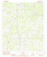
1982 Map of Stonewall
USGS Topo · Published 1982About this map
Stonewall and Keithville anchor this 1982 survey of the North Louisiana landscape, where the Caddo Parish and De Soto Parish border divides the region. The area is defined by an intricate network of waterways, including Boggy Bayou, Cypress Bayou, and Brush Bayou, which drain the lowlands. The industrial and logistical backbone of the era is evident in the path of the Kansas City Southern Ry, which runs north-to-south through both primary settlements. This provisional map reveals the transition between established railroad towns and the rural stretches surrounding them, featuring local landmarks such as the Strong Landing Strip. Genealogists and local historians can trace the early 1980s infrastructure and drainage patterns across smaller features like Johnson Branch, Foster Creek, and Buchanan Bayou.
Find a feature on this map
14 named features on this map. Tap any name to fly to it.
Don’t see what you’re looking for? This feature index may not catch every label — zoom into the map to look around manually.
Map Details
Editions of this 1982 Stonewall Map
2 editions found
Other maps of this area

1941 · Forbing
USGS Topo · 1:31,680

1945 · Grand Cane
USGS Topo · 1:62,500

1945 · Greenwood
USGS Topo · 1:62,500

1945 · Mansfield
USGS Topo · 1:62,500

1947 · Mansfield
USGS Topo · 1:62,500

1948 · Caspiana
USGS Topo · 1:62,500

1955 · Shreveport
USGS Topo · 1:250,000

1955 · Shreveport East
USGS Topo · 1:24,000

1955 · Caspiana
USGS Topo · 1:62,500
1955 · Shreveport West
USGS Topo · 1:24,000