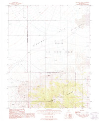
1987 Map of Stonewall Spring
USGS Topo · Published 1987About this map
Stonewall Mountain dominates the southern landscape of this high-desert region in Nye County, where the terrain transitions into the vast Mud Flat Depression to the north. Surveyed in the late 1980s, the map reveals a stark contrast between natural landmarks and military geography, with the northern half largely designated as part of the Nellis Air Force Range. This administrative boundary creates a prominent Restricted Access Area across the central portion of the sheet.
Find a feature on this map
14 named features on this map. Tap any name to fly to it.
Don’t see what you’re looking for? This feature index may not catch every label — zoom into the map to look around manually.
Map Details
Editions of this 1987 Stonewall Spring Map
This is the sole edition of this map. No revisions or reprints were ever made.
Other maps of this area

1908 · Kawich
USGS Topo · 1:250,000

1908 · Lida
USGS Topo · 1:250,000

1913 · Lida
USGS Topo · 1:250,000

1942 · Tolicha Peak
USGS Topo · 1:125,000

1942 · Cactus Range
USGS Topo · 1:125,000

1945 · Goldfield
USGS Topo · 1:125,000

1952 · Cactus Spring
USGS Topo · 1:62,500

1952 · Goldfield
USGS Topo · 1:62,500

1954 · Goldfield
USGS Topo · 1:250,000

1955 · Goldfield
USGS Topo · 1:250,000