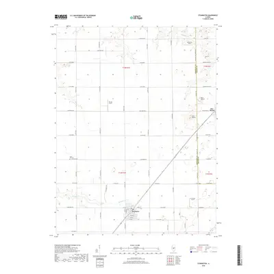
2018 Map of Stonington
USGS Topo · Published 2018About this map
Stonington anchors the southern portion of this central Illinois landscape, showing a grid of streets and residential blocks at the intersection of local routes like Co Rd 2000 N and N 1800 East Rd. The surrounding terrain is defined by its agricultural layout and significant drainage systems, including the winding Buckhart Cr and Mosquito Cr. The map reveals a high concentration of private aviation sites, such as Mc Christy Airport and Mc Coy Airport, which suggest the importance of aerial access for local farm operations or recreation.
Find a feature on this map
57 named features on this map. Tap any name to fly to it.
Don’t see what you’re looking for? This feature index may not catch every label — zoom into the map to look around manually.
Map Details
Editions of this 2018 Stonington Map
This is the sole edition of this map. No revisions or reprints were ever made.
Other maps of this area

1923 · Taylorville
USGS Topo · 1:62,500

1925 · Taylorville
USGS Topo · 1:62,500

1952 · Assumption
USGS Topo · 1:62,500

1954 · Niantic
USGS Topo · 1:62,500

1954 · Mechanicsburg
USGS Topo · 1:62,500

1958 · Decatur
USGS Topo · 1:250,000

1961 · Decatur
USGS Topo · 1:250,000

1974 · Willeys
USGS Topo · 1:24,000

1982 · Harristown
USGS Topo · 1:24,000
1982 · Stonington
USGS Topo · 1:24,000