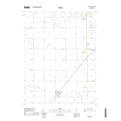
2021 Map of Stonington
USGS Topo · Published 2021About this map
Stonington serves as the central hub of this agricultural landscape in central Illinois, situated at the junction of Co Hwy 4 and N Main St. The surrounding terrain is defined by its subtle glacial features, most notably the elevations of Blue Mound and Long Mound which rise above the surrounding prairie. The region's drainage is managed by a network of waterways including Mosquito Cr and Buckhart Cr, with rural aviation playing a visible role in local transit as evidenced by Noland Farms RLA Airport, McCoy Airport, and McChristy Airport. Genealogical interest is anchored by the presence of Hall Cem near the Macon County line and Mount Zion Cem further west, both providing vital links to the area's early settlement history. The map meticulously records the grid of rural roads, such as Mosquito Creek Rd and Blue-Mound Rd, that has structured this farming community for generations.
Find a feature on this map
49 named features on this map. Tap any name to fly to it.
Don’t see what you’re looking for? This feature index may not catch every label — zoom into the map to look around manually.
Map Details
Editions of this 2021 Stonington Map
This is the sole edition of this map. No revisions or reprints were ever made.
Other maps of this area

1923 · Taylorville
USGS Topo · 1:62,500

1925 · Taylorville
USGS Topo · 1:62,500

1952 · Assumption
USGS Topo · 1:62,500

1954 · Niantic
USGS Topo · 1:62,500

1954 · Mechanicsburg
USGS Topo · 1:62,500

1958 · Decatur
USGS Topo · 1:250,000

1961 · Decatur
USGS Topo · 1:250,000

1974 · Willeys
USGS Topo · 1:24,000

1982 · Harristown
USGS Topo · 1:24,000
1982 · Stonington
USGS Topo · 1:24,000