
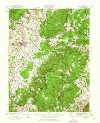
1929 Map of Stony Man
USGS Topo · Published 1929About this map
Stony Man and the high ridges of the Blue Ridge dominate this survey, which documents the landscape during the establishment of Shenandoah National Park. The map includes the proposed boundaries for the park, capturing a moment when mountain communities and backcountry shelters existed alongside the emerging tourist infrastructure of the Lee Highway and the Appalachian Trail. Along the valley floor, the Norfolk and Western Ry connects the town of Stanley and Luray, while the foothills are dotted with small mountain schools like the President Hoover Community Sch and the Thornton Gap Sch. This transitional period is further evidenced by the presence of local landmarks such as St Luke Episcopal Mission and the Sexton Shelter, set against the dramatic elevations of Old Rag Mountain and Hawksbill Mtn. The detailed mapping of gaps and hollows, such as Fishers Gap and Dark Hollow, reveals the complex network of trails and roads that historically linked these isolated settlements before the park's full formation.
Find a feature on this map
83 named features on this map. Tap any name to fly to it.
Don’t see what you’re looking for? This feature index may not catch every label — zoom into the map to look around manually.
Map Details
Editions of this 1929 Stony Man Map
2 editions found
Other maps of this area

1892 · Woodstock
USGS Topo · 1:125,000

1892 · Gordonsville
USGS Topo · 1:125,000

1892 · Harrisonburg
USGS Topo · 1:125,000

1893 · Luray
USGS Topo · 1:125,000

1905 · Luray
USGS Topo · 1:125,000

1923 · Edinburg
USGS Topo · 1:62,500

1930 · Madison
USGS Topo · 1:48,000

1933 · Stony Man
USGS Topo · 1:62,500

1933 · Madison
USGS Topo · 1:62,500

1937 · Elkton
USGS Topo · 1:62,500