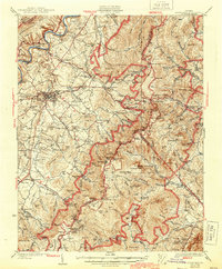
1933 Map of Stony Man
USGS Topo · Published 1944About this map
Luray and its surrounding Blue Ridge foothills are documented here during a transformative era of public land development. The map prominently features the newly established Shenandoah National Park, tracing the early routes of Skyline Drive and the Appalachian Trail as they crest the ridgeline. Near the high peaks of Stony Man and Hawksbill, the resort at Skyland stands as a focal point for early tourism, while the nearby Old Copper Mine suggests the area's earlier industrial ventures.
Find a feature on this map
91 named features on this map. Tap any name to fly to it.
Don’t see what you’re looking for? This feature index may not catch every label — zoom into the map to look around manually.
Map Details
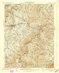
Editions of this 1933 Stony Man Map
3 editions found
Other maps of this area

1892 · Woodstock
USGS Topo · 1:125,000

1892 · Gordonsville
USGS Topo · 1:125,000

1892 · Harrisonburg
USGS Topo · 1:125,000

1893 · Luray
USGS Topo · 1:125,000

1905 · Luray
USGS Topo · 1:125,000

1923 · Edinburg
USGS Topo · 1:62,500

1929 · Stony Man
USGS Topo · 1:48,000

1930 · Madison
USGS Topo · 1:48,000

1933 · Stony Man
USGS Topo · 1:62,500

1933 · Madison
USGS Topo · 1:62,500