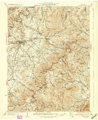
1933 Map of Stony Man
USGS Topo · Published 1933About this map
Luray stands at the western edge of this 1933 survey, a critical transition point between the Shenandoah River and the high ridges of the newly created Shenandoah National Park. This edition captures the landscape just as the Skyline Drive and Appalachian Trail were being established across the Blue Ridge, following the crest through Thornton Gap and past the Panorama Hotel. The map reveals a dense network of mountain communities and institutions that predated the park's full development, including the St. George Mission, Skyland, and numerous rural schoolhouses like Rattleburg School and Beth Eden School. To the west, the Norfolk and Western railroad services settlements such as Elgin Station and Stanley. Geologic and commercial interests are evidenced by the Luray Caverns and an Old Copper Mine situated near the headwaters of the Hughes River.
Find a feature on this map
131 named features on this map. Tap any name to fly to it.
Don’t see what you’re looking for? This feature index may not catch every label — zoom into the map to look around manually.
Map Details
Editions of this 1933 Stony Man Map
3 editions found
Other maps of this area

1892 · Woodstock
USGS Topo · 1:125,000

1892 · Gordonsville
USGS Topo · 1:125,000

1892 · Harrisonburg
USGS Topo · 1:125,000

1893 · Luray
USGS Topo · 1:125,000

1905 · Luray
USGS Topo · 1:125,000

1923 · Edinburg
USGS Topo · 1:62,500

1929 · Stony Man
USGS Topo · 1:48,000

1930 · Madison
USGS Topo · 1:48,000

1933 · Stony Man
USGS Topo · 1:62,500

1933 · Madison
USGS Topo · 1:62,500