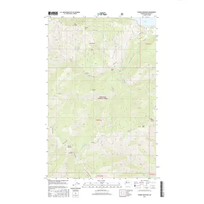
2017 Map of Stormy Mountain
USGS Topo · Published 2017About this map
Stormy Mountain and the Chelan Mountains dominate this high-altitude section of the Wenatchee National Forest. The landscape is defined by its drainage systems, where water flows from high peaks like Pot Peak and Lone Peak toward the northeastern corner where Lake Chelan sits. The intricate network of seasonal water sources, including Stormy Spring, Windy Camp Spring, and Beaver Spring, illustrates the hydrology of this steep terrain.
Find a feature on this map
38 named features on this map. Tap any name to fly to it.
Don’t see what you’re looking for? This feature index may not catch every label — zoom into the map to look around manually.
Map Details
Editions of this 2017 Stormy Mountain Map
This is the sole edition of this map. No revisions or reprints were ever made.
Other maps of this area

1899 · Methow
USGS Topo · 1:125,000

1901 · Chelan
USGS Topo · 1:125,000

1901 · Methow
USGS Topo · 1:125,000

1955 · Concrete
USGS Topo · 1:250,000

1957 · Wenatchee
USGS Topo · 1:250,000

1958 · Concrete
USGS Topo · 1:250,000

1962 · Concrete
USGS Topo · 1:250,000

1968 · South Navarre Peak
USGS Topo · 1:24,000
1968 · Big Goat Mtn
USGS Topo · 1:24,000

1968 · Tyee Mtn.
USGS Topo · 1:24,000