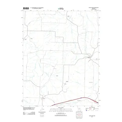
2011 Map of Stoutland
USGS Topo · Published 2011About this map
Stoutland and the surrounding Laclede County countryside are defined by a network of winding waterways and family burial grounds in this early 21st-century survey. The settlement of Delmar sits centrally, surrounded by generational landmarks including Barnett Cemetery and Lomax Cemetery. To the south, the village of Sleeper marks the approach to a more modern corridor where Garden Crest Rd skirts the edge of Spud Hollow. The landscape is etched by the drainage of Shakerag Creek and Dry Auglaize Creek, which carve through the terrain and influence the placement of rural roads like Lavender Ln and Keepsake Rd. This era of the landscape shows a mix of traditional Ozark settlement patterns and modern residential development, with numerous cemeteries such as Hillhouse Cemetery and Honey Cemetery providing essential reference points for local genealogical research.
Find a feature on this map
39 named features on this map. Tap any name to fly to it.
Don’t see what you’re looking for? This feature index may not catch every label — zoom into the map to look around manually.
Map Details
Editions of this 2011 Stoutland Map
This is the sole edition of this map. No revisions or reprints were ever made.
Other maps of this area

1933 · Stoutland
USGS Topo · 1:62,500

1938 · Stoutland
USGS Topo · 1:62,500

1941 · Lebanon
USGS Topo · 1:62,500

1943 · Richland
USGS Topo · 1:62,500

1943 · Lebanon
USGS Topo · 1:62,500

1943 · Drynob
USGS Topo · 1:62,500

1954 · Springfield
USGS Topo · 1:250,000

1954 · Drynob
USGS Topo · 1:62,500
1954 · Richland
USGS Topo · 1:62,500
1954 · Richland
USGS Topo · 1:24,000