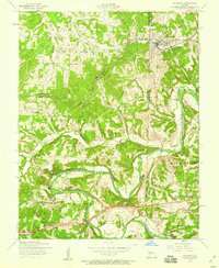
1954 Map of Richland
USGS Topo · Published 1959About this map
The town of Richland serves as the primary hub in this mid-century survey, situated at the intersection of Pulaski, Camden, and Laclede counties. The St Louis-San Francisco railroad cuts through the northern section of the map, providing a glimpse into the regional transportation network alongside U. S. 66 in the south. The rugged topography is defined by the winding course of the Gasconade River, which supports recreational sites such as Riverside Lodge and Wildwood Resort.
Find a feature on this map
32 named features on this map. Tap any name to fly to it.
Don’t see what you’re looking for? This feature index may not catch every label — zoom into the map to look around manually.
Map Details
Editions of this 1954 Richland Map
2 editions found
Other maps of this area

1933 · Stoutland
USGS Topo · 1:62,500

1938 · Stoutland
USGS Topo · 1:62,500

1941 · Lebanon
USGS Topo · 1:62,500

1943 · Richland
USGS Topo · 1:62,500

1943 · Lebanon
USGS Topo · 1:62,500

1943 · Drynob
USGS Topo · 1:62,500

1954 · Springfield
USGS Topo · 1:250,000

1954 · Drynob
USGS Topo · 1:62,500
1954 · Richland
USGS Topo · 1:62,500
1954 · Brownfield
USGS Topo · 1:24,000