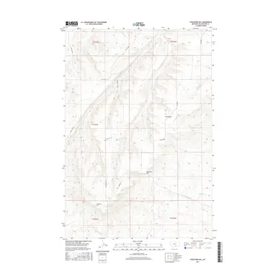
2017 Map of Stratford Hill
USGS Topo · Published 2017About this map
Stratford Hill and McCormick Hill anchor this topographic survey of Yellowstone County, defining a landscape carved by a dense network of drainages and seasonal watercourses. The terrain is characterized by the divide between the Blue Cr and Wyman Cr watersheds, where high ridges are accessed by local routes such as Stratford Hill Rd and Hillcrest Rd. To the south, the headwaters of Fourth-of-July Cr and Cottonwood Cr flow from the slopes of the prominent hills, while the eastern portion of the quadrangle is drained by Kent Cr and Monument Cr. This 2017 U.S. Geological Survey map illustrates a contemporary view of these Montana highlands, showing how modern ranch roads and property boundaries follow the natural contours of the drainages.
Find a feature on this map
21 named features on this map. Tap any name to fly to it.
Don’t see what you’re looking for? This feature index may not catch every label — zoom into the map to look around manually.
Map Details
Editions of this 2017 Stratford Hill Map
This is the sole edition of this map. No revisions or reprints were ever made.
Other maps of this area

1893 · Huntley
USGS Topo · 1:125,000

1954 · Billings
USGS Topo · 1:250,000

1956 · Yegen
USGS Topo · 1:24,000

1956 · Mossmain
USGS Topo · 1:24,000

1957 · Billings
USGS Topo · 1:250,000

1958 · Billings
USGS Topo · 1:250,000

1967 · Deep Creek
USGS Topo · 1:24,000

1967 · Pryor
USGS Topo · 1:24,000
1967 · Mossmain SW
USGS Topo · 1:24,000

1967 · Soda Springs NW
USGS Topo · 1:24,000