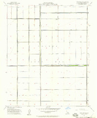
1954 Map of Stratford SE
USGS Topo · Published 1957About this map
Tulare Lake Bed defines the character of this mid-century landscape in Kings County, where the once-vast freshwater basin has been reclaimed for intensive agriculture. The map illustrates a highly engineered environment, dominated by a grid of levees and irrigation structures designed to manage water in this flat terrain. The Kings River flows south through the center of the sheet, constrained by the Central Avenue Levee, while the Tule River crosses the southern portion of the lake bed. This period of land management is evidenced by the numerous wells and the utility infrastructure of the Midlake Substation. The presence of named embankments such as the Lovelace Levee, Goldberg Levee, and Cohn Levee highlights the complex network of private and public efforts to control the hydrologic cycle for the benefit of the surrounding farmlands.
Find a feature on this map
18 named features on this map. Tap any name to fly to it.
Don’t see what you’re looking for? This feature index may not catch every label — zoom into the map to look around manually.
Map Details
Editions of this 1954 Stratford SE Map
2 editions found
Other maps of this area

1914 · Lost Hills
USGS Topo · 1:125,000

1929 · Guernsey
USGS Topo · 1:31,680

1929 · Stratford
USGS Topo · 1:31,680

1929 · Westhaven
USGS Topo · 1:31,680

1930 · Middle Dome
USGS Topo · 1:31,680

1931 · Harvester
USGS Topo · 1:31,680

1932 · El Rico Ranch
USGS Topo · 1:31,680

1932 · Dudley Ridge
USGS Topo · 1:31,680

1933 · Kettleman City
USGS Topo · 1:31,680

1933 · Chatom Ranch
USGS Topo · 1:31,680