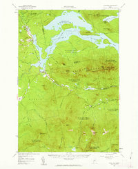
1956 Map of Stratton
USGS Topo · Published 1962About this map
Bigelow Mountain dominates the central landscape of this Maine survey, serving as a backdrop for the sprawling Flagstaff Lake. The map captures the region in the mid-1950s, documenting a network of summits including Sugarloaf Mtn, Crocker Mtn, and Spaulding Mtn. High-altitude routes like the Appalachian Trail and the Fire Warden Trail traverse the ridgelines, while the valley floor shows the transition from earlier industrial uses to recreation.
Find a feature on this map
70 named features on this map. Tap any name to fly to it.
Don’t see what you’re looking for? This feature index may not catch every label — zoom into the map to look around manually.
Map Details
Editions of this 1956 Stratton Map
3 editions found
Other maps of this area

1925 · Pierce Pond
USGS Topo · 1:48,000

1927 · Pierce Pond
USGS Topo · 1:62,500

1928 · Chain Lakes
USGS Topo · 1:48,000

1928 · Spencer
USGS Topo · 1:48,000

1928 · Dead River
USGS Topo · 1:62,500

1928 · Stratton
USGS Topo · 1:48,000

1929 · Phillips
USGS Topo · 1:48,000

1930 · Kingfield
USGS Topo · 1:48,000

1931 · Dead River
USGS Topo · 1:48,000

1932 · Phillips
USGS Topo · 1:62,500