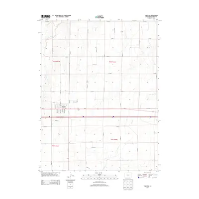
2013 Map of Stratton
USGS Topo · Published 2013About this map
Stratton serves as the central hub of this eastern Colorado landscape, situated along the critical transportation corridor of Us-24 E and the Interstate. The town's grid is clearly defined by several state-named avenues, including Kansas Ave, Nebraska Ave, and New York Ave. For genealogists and local historians, the map identifies Clairmont Cem and Calvary Cem just outside the main settlement. The surrounding High Plains terrain is marked by seasonal drainage patterns, such as Sevenmile Cr, Landsman Cr, and Dry Gulch. Agricultural operations like Triple H Farms underscore the rural character of the region, where a dense network of section-line roads, such as Co Road 30 and Co Road AA, facilitates movement between large farmsteads and the town center.
Find a feature on this map
47 named features on this map. Tap any name to fly to it.
Don’t see what you’re looking for? This feature index may not catch every label — zoom into the map to look around manually.
Map Details
Editions of this 2013 Stratton Map
This is the sole edition of this map. No revisions or reprints were ever made.
Other maps of this area

1954 · Limon
USGS Topo · 1:250,000

1957 · Limon
USGS Topo · 1:250,000

1958 · Limon
USGS Topo · 1:250,000

1969 · Alpine Ranch NE
USGS Topo · 1:24,000

1969 · Settlement
USGS Topo · 1:24,000

1969 · Tuttle
USGS Topo · 1:24,000

1969 · Bethune
USGS Topo · 1:24,000

1969 · Burlington 3 NW
USGS Topo · 1:24,000

1969 · Stratton
USGS Topo · 1:24,000
1970 · South of Bethune
USGS Topo · 1:24,000