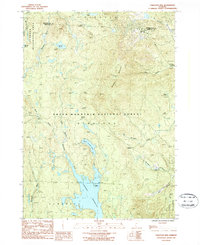
1986 Map of Stratton Mtn
USGS Topo · Published 1987About this map
Stratton Mountain dominates this mid-1980s terrain, a high-altitude landscape defined by the expansive Somerset Reservoir to the south and a network of glacial ponds including Stratton Pond and Bourn Pond. Most of the area is protected under the Green Mountain National Forest and the Lye Brook Wilderness Area, where the famous Appalachian Trail and Long Appalachian Trail wind across the ridges. The map captures a moment when the Vermont backcountry was largely centered on recreational conservation and water management, with the Deerfield River and its East Branch feeding the reservoir. Evidence of early settlement patterns remains visible in the steep drainage of Pike Hollow and the scattered Cem markers, while the town boundaries of Winhall, Stratton, and Somerset reflect the region's historic civil divisions.
Find a feature on this map
28 named features on this map. Tap any name to fly to it.
Don’t see what you’re looking for? This feature index may not catch every label — zoom into the map to look around manually.
Map Details
Editions of this 1986 Stratton Mtn Map
Other maps of this area

1889 · Wilmington
USGS Topo · 1:62,500

1891 · Wilmington
USGS Topo · 1:62,500

1894 · Londonderry
USGS Topo · 1:62,500

1894 · Equinox
USGS Topo · 1:62,500

1896 · Equinox
USGS Topo · 1:62,500

1898 · Bennington
USGS Topo · 1:62,500

1899 · Londonderry
USGS Topo · 1:62,500

1899 · Wilmington
USGS Topo · 1:62,500

1900 · Taconic
USGS Topo · 1:125,000

1900 · Equinox
USGS Topo · 1:62,500