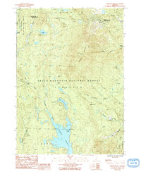
1986 Map of Stratton Mtn
USGS Topo · Published 1991About this map
Stratton Mountain dominates this high-country landscape, where the Appalachian National Scenic Trail winds through the dense timber of the Green Mountain National Forest. The map captures a high-elevation water system characterized by glacial features and early-century recreational development, anchored by the northern reaches of the Somerset Reservoir and the tranquil Stratton Pond. Remote settlements and geographical landmarks like Stratton Bush and Pike Hollow are situated among the headwaters of several drainages, including the Winhall River and the East Branch Deerfield River.
Find a feature on this map
24 named features on this map. Tap any name to fly to it.
Don’t see what you’re looking for? This feature index may not catch every label — zoom into the map to look around manually.
Map Details
Editions of this 1986 Stratton Mtn Map
Other maps of this area

1889 · Wilmington
USGS Topo · 1:62,500

1891 · Wilmington
USGS Topo · 1:62,500

1894 · Londonderry
USGS Topo · 1:62,500

1894 · Equinox
USGS Topo · 1:62,500

1896 · Equinox
USGS Topo · 1:62,500

1898 · Bennington
USGS Topo · 1:62,500

1899 · Londonderry
USGS Topo · 1:62,500

1899 · Wilmington
USGS Topo · 1:62,500

1900 · Taconic
USGS Topo · 1:125,000

1900 · Equinox
USGS Topo · 1:62,500