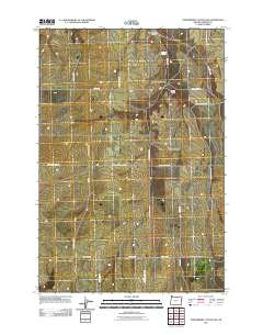
2011 Map of Strawberry Canyon SW
USGS Topo · Published 2011About this map
McDaid Springs and McDevitt Springs serve as vital water markers in this high-desert landscape of Morrow County, Oregon. The terrain is defined by the deep incisions of Strawberry Canyon and Little Juniper Canyon, which break up the geometric grid of agricultural and access roads. The prevalence of family-named thoroughfares such as Proudfoot Rd, Barak Martin Rd N, and Lloyd Morgan Rd reflects a landscape primarily organized around private landholdings and long-standing ranching estates. The intersection of Strawberry West Rd and Strawberry East Rd acts as a central axis for the area, while the presence of Lexington Grange Rd suggests the historical importance of the local Grange movement in supporting this rural farming community.
Find a feature on this map
22 named features on this map. Tap any name to fly to it.
Don’t see what you’re looking for? This feature index may not catch every label — zoom into the map to look around manually.
Map Details
Editions of this 2011 Strawberry Canyon SW Map
This is the sole edition of this map. No revisions or reprints were ever made.
Other maps of this area

1906 · Blalock Island
USGS Topo · 1:125,000

1908 · Blalock Island
USGS Topo · 1:125,000

1953 · Pendleton
USGS Topo · 1:250,000

1956 · Pendleton
USGS Topo · 1:250,000

1968 · Swaggart Buttes
USGS Topo · 1:24,000

1968 · Lexington
USGS Topo · 1:24,000

1968 · Ione North
USGS Topo · 1:24,000

1968 · Ione South
USGS Topo · 1:24,000
1968 · Strawberry Canyon NE
USGS Topo · 1:24,000
1968 · Strawberry Canyon SE
USGS Topo · 1:24,000