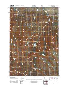
2011 Map of Strawberry Mountain
USGS Topo · Published 2011About this map
Strawberry Mountain dominates this high-elevation terrain in eastern Oregon, serving as the centerpiece for a complex network of glacial cirques and alpine basins. The landscape is defined by its water sources, from the isolated waters of Strawberry Lake and Little Strawberry Lake to the named flows of Strawberry Creek and Onion Creek. Evidence of early industrial activity persists at the Marks-Thompson Mine in the northwest, while the presence of the Strawberry Lake Camp and Indian Springs Campground indicates the area's established role for outdoor recreation.
Find a feature on this map
48 named features on this map. Tap any name to fly to it.
Don’t see what you’re looking for? This feature index may not catch every label — zoom into the map to look around manually.
Map Details
Editions of this 2011 Strawberry Mountain Map
This is the sole edition of this map. No revisions or reprints were ever made.
Other maps of this area

1940 · John Day
USGS Topo · 1:62,500

1943 · John Day
USGS Topo · 1:62,500

1955 · Canyon City
USGS Topo · 1:250,000

1959 · Canyon City
USGS Topo · 1:250,000

1959 · Prairie City
USGS Topo · 1:62,500

1961 · Logan Valley
USGS Topo · 1:62,500

1961 · Seneca
USGS Topo · 1:62,500
1972 · Castle Creek
USGS Topo · 1:24,000
1972 · Pine Creek Mtn
USGS Topo · 1:24,000

1978 · John Day
USGS Topo · 1:100,000