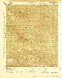
1944 Map of Strawberry Peak
USGS Topo · Published 1944About this map
Madulce Peak serves as the dominant high point in this remote section of the Los Padres National Forest during the mid-1940s. This wartime survey, revised by the Corps of Engineers, shows the critical fire lookout infrastructure of the era, specifically the Madulce Peak Lookout and the nearby Madulce Guard Sta. The landscape is defined by a dense network of canyons and drainage systems, including Alamar Canyon and Chokecherry Canyon, which feed into major watercourses like Mono Creek. The presence of the Don Victor Valley in the eastern portion of the sheet highlights the few level clearings amidst the high ridges of Alamar Hill and Loma Pelona. This map records the early 20th-century forest management footprint, preserving the names of remote backcountry landmarks and seasonal water sources like Agua Caliente Creek.
Find a feature on this map
15 named features on this map. Tap any name to fly to it.
Don’t see what you’re looking for? This feature index may not catch every label — zoom into the map to look around manually.
Map Details
Editions of this 1944 Strawberry Peak Map
This is the sole edition of this map. No revisions or reprints were ever made.
Other maps of this area

1902 · Santa Ynez
USGS Topo · 1:125,000

1903 · Mt. Pinos
USGS Topo · 1:125,000

1905 · Santa Ynez
USGS Topo · 1:125,000

1942 · Little Pine Mountain
USGS Topo · 1:24,000

1943 · Big Pine Mountain
USGS Topo · 1:31,680

1943 · Rancho Nuevo Creek
USGS Topo · 1:24,000

1943 · Old Man Mountain
USGS Topo · 1:24,000

1943 · Cuyama Peak
USGS Topo · 1:24,000

1943 · Hildreth Peak
USGS Topo · 1:24,000
1943 · Fox Mountain
USGS Topo · 1:24,000