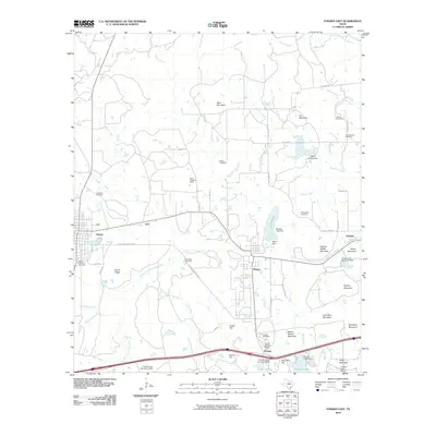
2010 Map of Strawn East
USGS Topo · Published 2010About this map
Thurber, once a bustling company coal town, sits at the heart of this landscape alongside the Thurber Historic District. The industrial history of the region is written into the terrain, where Coal Mine Mountain and the Boles Rector Oil Field signal the extraction of natural resources that drove local development. The map details a series of settlements including Mingus, Strawn, and Gordon, connected by a network of ranch roads and geographic features like the South Fork Palo Pinto Creek. Genealogists will find a wealth of specific data points through numerous local burial grounds, such as McSpadden Cemetery, Smith Cemetery, and Mount Marion Cemetery. The topography is marked by distinctive elevations including Steam Shovel Mountain and Italian Hill, while the local infrastructure is supported by several reservoirs, including Lake Mingus and Thurber Lake.
Find a feature on this map
66 named features on this map. Tap any name to fly to it.
Don’t see what you’re looking for? This feature index may not catch every label — zoom into the map to look around manually.
Map Details
Editions of this 2010 Strawn East Map
This is the sole edition of this map. No revisions or reprints were ever made.
Other maps of this area

1890 · Stephenville
USGS Topo · 1:125,000

1890 · Breckenridge
USGS Topo · 1:125,000

1891 · Palo Pinto
USGS Topo · 1:125,000

1894 · Eastland
USGS Topo · 1:125,000

1918 · Palo Pinto
USGS Topo · 1:125,000

1920 · Stephenville
USGS Topo · 1:125,000

1954 · Abilene
USGS Topo · 1:250,000

1958 · Abilene
USGS Topo · 1:250,000

1959 · Gordon
USGS Topo · 1:62,500
1965 · Reddy Mountain
USGS Topo · 1:24,000