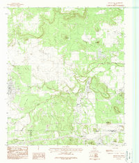
1984 Map of Strawn East
USGS Topo · Published 1984About this map
Strawn and Mingus anchor this mid-1980s landscape, illustrating the enduring settlement patterns of the Texas coal-mining country. The topography is defined by significant ridges and family-named heights, including Dickson Walker Mountain and Wolf Mountain. The industrial legacy of the region is written directly onto the land, evidenced by features such as Coal Mine Mountain and Steam Shovel Mountain south of Thurber. Water management is central to the area's development, with Lake Mingus and Lake C B Long providing significant reservoirs amid the winding course of Palo Pinto Creek. The convergence of Palo Pinto, Eastland, and Erath counties occurs in the southern portion of the map, near the community of New York Hill, showing how early jurisdictional boundaries followed the local terrain.
Find a feature on this map
46 named features on this map. Tap any name to fly to it.
Don’t see what you’re looking for? This feature index may not catch every label — zoom into the map to look around manually.
Map Details
Editions of this 1984 Strawn East Map
This is the sole edition of this map. No revisions or reprints were ever made.
Other maps of this area

1890 · Stephenville
USGS Topo · 1:125,000

1890 · Breckenridge
USGS Topo · 1:125,000

1891 · Palo Pinto
USGS Topo · 1:125,000

1894 · Eastland
USGS Topo · 1:125,000

1918 · Palo Pinto
USGS Topo · 1:125,000

1920 · Stephenville
USGS Topo · 1:125,000

1954 · Abilene
USGS Topo · 1:250,000

1958 · Abilene
USGS Topo · 1:250,000

1959 · Gordon
USGS Topo · 1:62,500
1965 · Reddy Mountain
USGS Topo · 1:24,000